Analyzing the Role of Vegetation in Urban Heat Islands
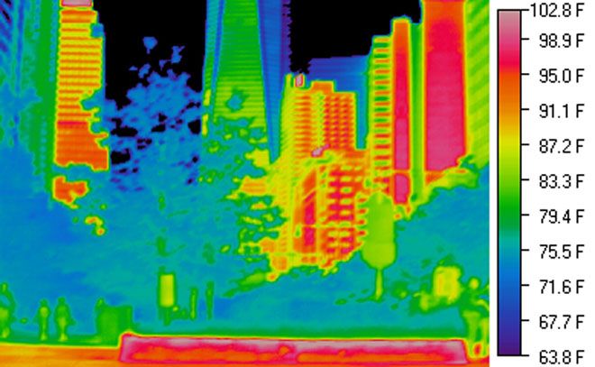
This project investigates how vegetation influences temperature in urban heat islands. By comparing areas with varying plant cover, students can assess the cooling effects of vegetation.
This project investigates how urbanization contributes to heat islands. By measuring temperature differences in urban and rural areas, students will learn about the impact of city planning on local climates.

If urban areas are compared to rural areas, then urban areas will have significantly higher temperatures due to heat island effects.
As an Amazon Associate, this site earns from qualifying purchases.
Identify and select urban and rural locations for temperature measurement.
Plan a schedule to measure temperatures at the same time of day.
Use thermometers to record temperatures in each location.
Document environmental factors such as vegetation and building materials.
Repeat temperature measurements over several days to ensure accuracy.
Analyze data to identify patterns and temperature differences.
Create graphs to illustrate the temperature variations.
Prepare a presentation discussing the implications of heat islands.
The urban location is expected to show higher temperatures than the rural area, demonstrating the heat island effect. This will highlight how urbanization influences local climates.
Type of area (urban vs. rural)
Measured temperature
Time of day for measurement, Weather conditions, Instrumentation used
Ensure thermometers are handled carefully, especially if they contain mercury.
Use graphs to visually compare temperature data.
Include photos of the locations studied.
Discuss potential solutions to reduce urban heat.
Engage the audience with questions about urban planning.
Provide handouts summarizing findings and suggestions.
Late spring or summer is best for clear temperature differences.
Take measurements at the same time daily and avoid direct sunlight on the thermometer.
Yes, urban heat islands are a common phenomenon in cities worldwide.